3D Printed Landscape Gallery
The ability to create a landscape model opens up new avenues for engaging an audience with your research or project. These models can illustrate a real place or blend conceptual models with terrain. We have expertise in creating 3D printable landscapes from a variety of geospatial data sources, and we are interested in working with faculty and researchers to turn your ideas into a solid reality. Our high quality 3D printers are housed in the Geospatial Center MapperSpace.
Come see the 3D Printed Landscape Gallery on display in our Collaborative Space. If you are interested in being featured, fill out the form below!

The digital surface model (DSM, top) vs the final 3D printed model (bottom)

A model for Dr. Ogle's Roadway Engineering Design course.


The digital surface model (DSM, top) vs the final 3D printed model (bottom)
Our 3D Printers
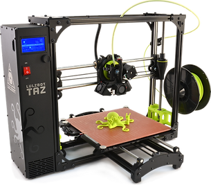
Lulzbot Taz 6
This high-quality printer is designed with an open-source concept. It can auto level its heated print bed for outstanding print quality and reliability.
-
Print Surface: Heated borosilicate glass bed covered with PEI film
-
Print Area: 11" x 11" x 9.8"
gCreate gMax 1.5+XT
This is an extra-tall large volume printer printer with a dual-zone heated bed with 36-point automatic leveling for excellent adhesion.
-
Print Surface: Heated borosilicate glass bed covered with custom BuildTak surface
-
Print Area: 16" x 16" x 21"
Both of our printers are compatible with a variety of print materials, such as ABS, PLA, HIPS, PVA, wood filled filaments, Polyester, PETT, bronze and copper filled filaments, Polycarbonate, Nylon, PETG, conductive PLA and ABS, UV luminescent filaments, PCTPE, PC-ABS, and more.

